
Follow us to Everest - Day 5, Deboche to Dingboche
- World Adventure Guides

- May 3, 2018
- 3 min read

Your morning’s walk begins gently through the dense woods of juniper and pine and ghostly copper birch, with their buff-coloured peeling bark. Once over the pontoon bridge above the Imja Khola, the path starts climbing towards the village of Pangboche and the views open up.

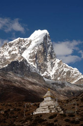
The impressive form of Ama Dablam dominates the horizon to the right, with its two snow-covered ridges reaching out either side of its steep domed summit.

The trek today will take around five to six hours of walking with a fair bit of height gain. Deboche is at 3710m and Dingboche is at 4410m so walk slowly and let your body acclimatise. You are starting to get quite high now so it is possible you may get a very slight headache when you arrive in Dingboche if you take things too fast.
The trail is lined by large chortens, prayer walls and elaborately painted rock faces; and you may see small herds of tahr, brown mountain goats. Above you, look out for lammergeiers, huge bearded vultures, as they circle effortlessly in the clear blue sky.
Before you reach Lower Pangboche you will pass through an impressive archway that spans the natural gap in the rocks. Be sure to look up at the elaborately painted ceiling inside the arch, which depicts a mandala, a spiritual teaching tool and a sacred symbol to both Buddhists and Hindus.

Just beyond the village of Lower Pangboche the trail will reach a well-used intersection from the left that comes down from Upper Pangboche and Phortse. There is a really nice monastery (Gompa) in Upper Pangboche if you have time to go up there, but this might be better left until you are on your way down as is a bit of a hike. Once you are on your way back down, if you want a different route back to the way you have come up, then via Upper Pangboche and Phortse is an amazing way to return. More on that later.

A further 30–45 minutes on from this intersection the village of Shomare is a good place for lunch. There are great views back along the morning’s trail.
From Shomare the trail rises. The terrain becomes more barren; the vegetation thins out and hugs the ground to cope with the strong winds that can blow up here. It is a huge change from even yesterday which was mostly in the trees. They have now gone or are very sparse.
You’ll see herds of yak dotted around the hills, but few houses. At a well-defined intersection, take the trail to the right. It leads down to cross the Lobuche Khola before climbing up again for the final 30 minutes of the day.
Your rest point for two nights is the large, very strung out village of Dingboche, remarkable for its intricate field patterns. There are plenty of lodges here.


In Dingboche is where those climbers going on to Island Peak will depart from the trail. If you have a look at the top map, you will be able to see their route on. Island Peak base camp is just on the very right side of the map.
But for You there will be another rest day here tomorrow. You have gained a lot of height today and it is import to allow your body to catch up. So perhaps a short walk in the direction of Island Peak base camp might be what you fancy or, there is is small gompa just above Dinboche which would give you a little more height and then back down again.
Enjoy your evening in Dingboche. Sometimes there are doctors here doing health checks for trekkers. Just ask at your lodge and they will know.
Rest day tomorrow.


Comments